Finding Our Center
(This article first appeared in Berkshire Magazine.)
By Felix Carroll
The geographic center of Berkshire County is not located somewhere fun, like the cloakroom at the Masonic Lodge, or the high-voltage lab at General Electric, or the pharmaceutical aisle in Price Chopper, or even James Taylor’s hot tub.
The geographic center of Berkshire County is not located somewhere fun, like the cloakroom at the Masonic Lodge, or the high-voltage lab at General Electric, or the pharmaceutical aisle in Price Chopper, or even James Taylor’s hot tub.
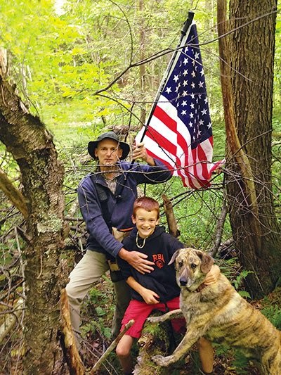
Still, it’s the very center of Berkshire County, and my search party and I landed upon it and planted a flag there. Here’s our story:
It took two afternoons, several tense standoffs with my occasionally mutinous cohorts, and the sorrowful surrender to the blood-collecting demands of a creatively limited assemblage of deer flies, but at 1:37 p.m. on June 22, history was made, as far as I know.
How were we certain we stood upon the geographic center of this noble county? By scientific method and a wild goose chase. Luckily, Berkshire County is shaped more or less like a rectangle—unlike, say, Essex County, which is shaped like a mini-India (that is to say, like a bug splat on a windshield), or Barnstable County, which is shaped like a thin arm flexed with pride before big biceps mattered.
Here in Berkshire County, you can draw a straight line between the distant extremities of Williamstown and Sandisfield and another straight line between Florida and Mount Washington. Those two lines intersect somewhere within cannon range of Greenridge Park in Dalton. Bingo! Before getting too excited, however, we saved ourselves time and potential starvation by recalling the fatal mistake made in 1846 by the Donner Party: They took a “shortcut” across the Rocky Mountains without Googling it first.
We Googled, and Google ushered us to the U.S. Census Bureau website, which lists the geographic center of Berkshire County at latitude 42.396128 and longitude 73.209889—not in Dalton at all.
Indeed, according to a free app I downloaded that evidently still has a few kinks to work out, the geographic center of Berkshire County is in West Sand Lake, New York. (That’s not a joke.) Naturally, my exploration team and I were a little skeptical, so I banged the smart phone on the kitchen table, but the free app stood by its findings.
Indeed, according to a free app I downloaded that evidently still has a few kinks to work out, the geographic center of Berkshire County is in West Sand Lake, New York. (That’s not a joke.) Naturally, my exploration team and I were a little skeptical, so I banged the smart phone on the kitchen table, but the free app stood by its findings.
“Just go straight to Google Maps, ya moron,” said a fellow explorer who holds the title of wife in a marital contract that includes my name. So I did what she told me to do, to my credit, and before you could say Marco Polo, Google Maps placed latitude 42.396128 and longitude 73.209889 in the town of Washington, by the northern edge of October Mountain State Forest. And we have a new Bingo!
Armed with a new mapping app that cost money, we made haste. But two things went horribly wrong. First: We didn’t bring snacks for the youngest member of the search party, my porter. Two: When we trekked a couple miles to the point indicated by Google Maps, our app begged to differ. We had overshot the mark by about a mile.
Distraught, demoralized, and getting on each other’s nerves, we turned back, drove home, and tried to pretend none of the above ever happened. That evening, I again typed the coordinates into Google Maps, and it turned out Google Maps had a sudden change of heart—this time placing the coordinates a mile farther to the southwest. You may be thinking, “That’s not possible. Google Maps doesn’t reconsider anything.” But it does, because it did, and the whole thing is weird, and I wonder if Edward Snowden knows anything about any of this.
The following day, we set off again, with snacks this time and a new attitude.
So here’s how to get to the geographical center of Berkshire County. Take New Lenox Road up into October Mountain State Forest, and park where the pavement ends. Hike the unmaintained road east about three-quarters of a mile. You’ll see a ramshackle dam to the left that impounds the old Millbrook Reservoir. Don’t abandon the trail and plunge north into the thick woods for about a half-hour as we did because that would be stupid. Instead, continue on the trail. About 100 feet past the reservoir, take a left into the woods for about 30 feet till you come to a tangle of prone pine trees piled like Pick Up Sticks. As your GPS of choice will probably indicate, you will not be in West Sand Lake, New York. You will be at latitude 42.396128 and longitude 73.209889—a standard-issue patch of mucky Berkshire woodlands.
Disappointingly, what you won’t find at the geographical center of Berkshire County is any sort of welcoming party handing out certificates of completion. No oracle on a tree branch granting you three wishes. No strange cosmic vibe or tear in the space-time continuum. Not even a place you’d want to picnic.
What you may find is the American flag we planted there, in Washington, festooned to a ski pole beside a Jack-in-the-pulpit. Do me a favor: I need my ski pole back.


Comments
Post a Comment